The
spring gushes out of the
ground in the park from the geological
museum near
Digne-les-Bains (South
French Alps).
It is in the territory of the “Réserve
Géologique de Haute-Provence”.
|
|
Geological
context
The locally observed rocks
are dated from
the secondary era. They were
formed between the Triassic ( - 250 million years)
and the Jurassic (
- 145 million years). There are three sorts of rocks : clays,
limestone and an alternation of marls and limestone.
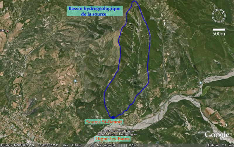
Hydrogeologic
context
The catchment
area 1 from
the St-Benoît spring is the Givaudan synclinal 2,
that is to say the Siron Mountain. In this area the rainwater
infiltrates in depth where it circulates then, to finally arise to
the spring. The underground rocks where the water circulates are
called aquifer.
|
|
1 Catchment
area ("bassin hydrogeologique"):
topographic area which collects the rain waters, which will
infiltrate into the mountain and then supply the spring.
2 Synclinal
:
geological structure in form of a drainpipe.
|
|
The
St Benoît spring’s characteristics …
The
spring water is drinkable,
it supplies the geological park’s administrative buildings. It is
also used to decorate the park: for the water path, the fountains,
the Japanese garden and other works of art.
This source is petrifying, i.e. that at the exit of water rocks are
formed, called tuffs or travertines.
|
 The St-Benoît
spring of Digne-les-Bains
The St-Benoît
spring of Digne-les-Bains